GLIFWC is an intertribal agency representing eleven Ojibwe Tribes in Minnesota, Wisconsin, and Michigan who reserved hunting, fishing and gathering rights in the 1836, 1837, 1842, and 1854 Treaties with the United States government.

Boundaries
-
River Segments Available for Open Water Spearing and Netting, February 2018
River segments available for open water spearing and netting in the Wisconsin portion of 1837 and 1842 Ceded Territories, updated February 2018. Revision after stipulation... -
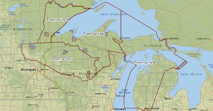
Ceded Territory Boundary v2.1
These data represent the boundaries of the 1836, 1837, 1842 and 1854 treaty areas of the Ojibwe ceded territories in Michigan, Minnesota and Wisconsin. The purpose of these data...

GLIFWC
These data are provided by Great Lakes Indian Fish and Wildlife Commission (GLIFWC). GLIFWC is an intertribal agency...
-
GLIFWC Public WMS
Open Geospatial Consortium Web Map Service (WMS). This data is provided by Great Lakes Indian Fish and Wildlife Commission (GLIFWC). GLIFWC is an intertribal agency representing... -
WI Manoomin Inventory, v2.2.1
This data is a representation of Water Body Identification Code (WBIC) delineated waters known to support manoomin (wild rice, Zizania spp.) within the Ceded Territories (Treaty...